
$2,500
About this home
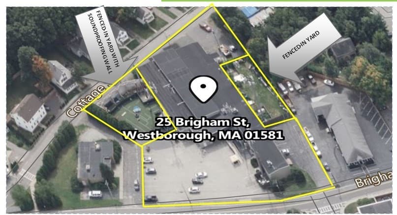
Land lease, not for sale. Located in Westboro just off the main rotary, with easy access to Rts. 495, 9 & 30, NOTE: SF IS APPROX. 4,300 S.F. FENCED-IN YARD SPACE - ASKING $2,500/m - Negotiable. Available NOW. Can be added to 4,100 s.f. of industrial space.
Property details
- MLS #
- 73228052
- Property type
- Commercial
- Subdivision
- N/A
- Status
- Active
- Days on market
- 893
- On market date
- April 24, 2024
- Stories
- N/A
- Total bathrooms
- N/A
- Garage spaces
- N/A
- Parking spaces
- N/A
- Lot size
- 0.11 acres
Location
Get directions →Nearby schools
Within 10 miles. School directory data from the National Center for Education Statistics (NCES), accessed via the Urban Institute Education Data API. Local Score is calculated by INNOVATE Real Estate; where a state rating is shown, it comes from that state's own official school report card (e.g. NC Dept. of Public Instruction, SC Report Card).
- Enrollment
- 367
- Student:teacher ratio
- 11.5:1
- District
- Westborough
- Enrollment
- 592
- Student:teacher ratio
- 10.2:1
- District
- Westborough
- Enrollment
- 1,178
- Student:teacher ratio
- 12.1:1
- District
- Westborough
Walkability
Blended score for Westborough's center, calculated by INNOVATE Real Estate from two sources: the EPA's National Walkability Index (street network, transit, land-use mix) and Google Places amenity data (what's actually reachable on foot from this point). 60% EPA National Walkability Index + 40% nearby-amenity density (Google Places).
Mortgage calculator
Estimate only - actual rate and payment depend on your lender, credit, and loan program.
Adjust tax / insurance estimates
Similar homes you might like
Data source: Listing information provided by MLS Property Information Network via Trestle/CoreLogic. Last updated June 27, 2026.
Information herein deemed reliable but not guaranteed; all measurements, school assignments, HOA fees, taxes, and feature lists are approximate and should be independently verified. Equal Housing Opportunity.