
$1,300,000
About this home
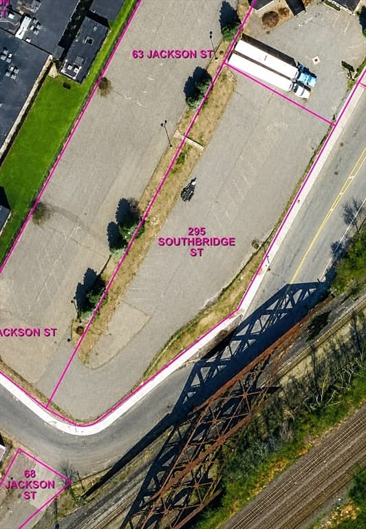
295 Southbridge Street is a ±0.63-acre (27,443± SF) paved, unimproved development site positioned at the convergence of SouthbridgeStreet and Jackson Street in Worcester's Canal District. Offered at $1,300,000, the property presents a rare opportunity to acquire ashovel-ready parcel in one of Central New England's most active urban development corridors, carrying BG-6.0 zoning — thehighest-density commercial classification in the City of Worcester. The parcel is offered as a standalone lot. The abutting parcels to the north (63 Jackson St, ±0.96 ac) and northeast (241 Southbridge St,±0.48 ac, with existing building) have been sold to separate owners and are not available for assemblage.BG-6.0 zoning permits a 6:1 floor-area ratio by right with no maximum height limit and no minimum setbacks. Multifamily high-rise andlow-rise, hotel, medical, office, retail, life sciences, and cannabis dispensary uses are all permitted by right. See attached OM
Property details
- MLS #
- 73535513
- Property type
- Commercial
- Subdivision
- N/A
- Status
- Active
- Days on market
- 118
- On market date
- June 13, 2026
- Stories
- N/A
- Total bathrooms
- N/A
- Garage spaces
- N/A
- Parking spaces
- N/A
- Lot size
- 0.63 acres
Location
Get directions →Nearby schools
Within 10 miles. School directory data from the National Center for Education Statistics (NCES), accessed via the Urban Institute Education Data API. Local Score is calculated by INNOVATE Real Estate; where a state rating is shown, it comes from that state's own official school report card (e.g. NC Dept. of Public Instruction, SC Report Card).
- Enrollment
- 358
- Student:teacher ratio
- 14.3:1
- District
- Worcester
- Enrollment
- 781
- Student:teacher ratio
- 13.7:1
- District
- Worcester
- Enrollment
- 527
- Student:teacher ratio
- 13.5:1
- District
- Worcester
Walkability
Blended score for Worcester's center, calculated by INNOVATE Real Estate from two sources: the EPA's National Walkability Index (street network, transit, land-use mix) and Google Places amenity data (what's actually reachable on foot from this point). 60% EPA National Walkability Index + 40% nearby-amenity density (Google Places).
Market position
How this listing compares to current activity in Worcester, from live MLS data.
Mortgage calculator
Estimate only - actual rate and payment depend on your lender, credit, and loan program.
Adjust tax / insurance estimates
Similar homes you might like
Data source: Listing information provided by MLS Property Information Network via Trestle/CoreLogic. Last updated August 22, 2026.
Information herein deemed reliable but not guaranteed; all measurements, school assignments, HOA fees, taxes, and feature lists are approximate and should be independently verified. Equal Housing Opportunity.